The Potential and Advantages of the Use of Drones and Associated Technologies to Monitor Environmental Impacts


This article has been supplied.
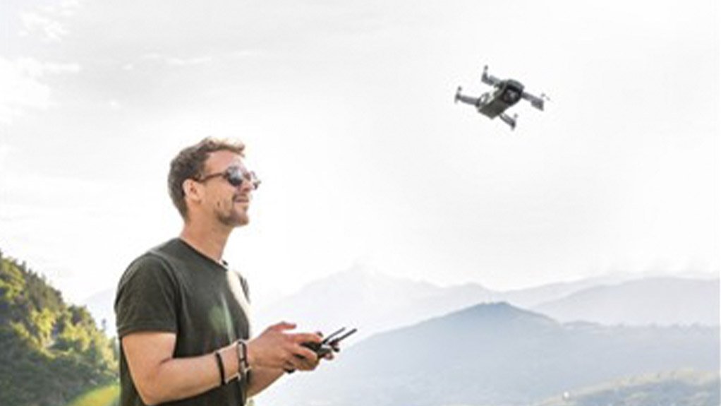
(Virtual Showroom): Technology around the world is advancing rapidly and is becoming more prominent in many spheres including environmental monitoring. Drone technology has the potential to become a powerful means of monitoring environmental changes and impacts on a larger scale.
One such potential is monitoring the spread of alien vegetation which is a major concern in a South African context. Drones can initially be used to identify the extent of alien vegetation proliferation where access may be limited, particularly in dense bush clumps. Dominant alien species can be identified on a holistic scale and suitable clearance measures identified and subsequently implemented (Holden, et al., 2021) (Dash, et al., 2019) (Dvořák, et al., 2015). In such an instance, drone technology provides a “birds eye view” and is able to capture aerial photography which can then be analysed. Depending on the resolution of the aerial photography captured by the drone and experience of the interpreter, the extent of alien vegetation per species can be determined, which reduces time spent out in the field and labour costs. Again, depending on the resolution of the aerial photography captured, it is possible to import the image into a Remote Sensing Software to run various Vegetation Indices which allows the user to accurately map out different vegetation species based on their spectral properties (Yang, 2007) (Candiago, et al., 2015). This also has the potential to monitor biodiversity changes within a certain landscape.
Drones can also be used to monitor rivers, by flying along the length of the river reach that requires surveying, information can be relayed back to the user as real time video or pictures and can be captured for later analysis (Holden, et al., 2021). These pictures and/or real time video can be analysed, for any blockages, major silt build up, or diversions and the necessary mitigation and/or rehabilitation measures implemented. Depending on the capability of the drone, GPS points can be captured of areas of interest for further infield investigation. This mitigates the need for large teams to traverse the river on foot thus saving time and money.
Within protected areas the use of drone technology has been very successful. Drones have been used in ecosystem monitoring to monitor habitat degradation and images taken to analyse the effectiveness and performance of conservation actions. Habitat assessments have also been done to identify areas that would be more suitable for relocation of endangered or threatened species. Drones have been widely used in forest monitoring where the distribution, biomass, composition, and structure of the forest have been analysed and the information used to implement effective habitat restoration plans (López & Mulero-Pázmány, 2019).
Drones can also be used for environmental management in assisting with soil (measured using Normalised Difference Bare Soil Index (NDBSI)), water (measured using Normalized Difference Water Index (NDWI), Modified NDWI (MNDWI), and Automated Water Extraction Index (AWEI)), and air (measured using Air Quality Index (AQI)) quality sampling, erosion monitoring (measured using NDVI, fractional vegetation coverage, NDBSI and slope), forest and bush withdraw (measured using Normalised Difference Vegetation Index (NDVI), and NDBSI), habitat degradation (measured using NDVI and NDBSI), oil spills (measured using NDVI, NDWI, Normalised Difference Red Edge (RENDVI), Green NDVI (GNDVI)), wild fires (measured using NDVI and NDBSI), desertification of areas (measured using NDVI, Top Grain Soil Index (TGSI)) and drought (measured using NDVI, Temperature Condition Index (TCI), Vegetation Condition Index (VCI), Vegetation Condition Index (VHI)) impact at different stages of the event (López & Mulero-Pázmány, 2019).
Regarding construction sites and industrial facilities, drones can be used to inspect the sites and facilities from a “birds eye view”. This perspective can be used to monitor the construction site ensuring that construction activities remain within the authorised construction layout and activities are not indirectly impacting the surrounding environment. (López & Mulero-Pázmány, 2019).
Taking the above into consideration, drones have vast potential in the environmental sector. One of the major advantages in the holistic view they provide of the receiving environment relative to a construction site.
Environmental Assurance (Pty) Ltd. (ENVASS) offer highly skilled and suitably qualified teams of Environmental Specialists who are always ready to review and implement monitoring programmes for a new project or existing activities.
Article Enquiry
Email Article
Save Article
Feedback
To advertise email advertising@creamermedia.co.za or click here
Research Reports

Projects

Latest Multimedia

Latest News


Showroom

ROSOND provides fast, efficient, safe, and cost-effective drilling and grouting services to mining and exploration industries throughout Africa.
VISIT SHOWROOM
AirNox (Pty) Ltd is a level 1 BBBEE manufacturer of complete AdBlue® solutions for operators of SCR diesel engines and AUS40 across South Africa...
VISIT SHOWROOM


Announcements
What's On
Subscribe to improve your user experience...
Option 1 (equivalent of R125 a month):
Receive a weekly copy of Creamer Media's Engineering News & Mining Weekly magazine
(print copy for those in South Africa and e-magazine for those outside of South Africa)
Receive daily email newsletters
Access to full search results
Access archive of magazine back copies
Access to Projects in Progress
Access to ONE Research Report of your choice in PDF format
Option 2 (equivalent of R375 a month):
All benefits from Option 1
PLUS
Access to Creamer Media's Research Channel Africa for ALL Research Reports, in PDF format, on various industrial and mining sectors
including Electricity; Water; Energy Transition; Hydrogen; Roads, Rail and Ports; Coal; Gold; Platinum; Battery Metals; etc.
Already a subscriber?
Forgotten your password?
Receive weekly copy of Creamer Media's Engineering News & Mining Weekly magazine (print copy for those in South Africa and e-magazine for those outside of South Africa)
➕
Recieve daily email newsletters
➕
Access to full search results
➕
Access archive of magazine back copies
➕
Access to Projects in Progress
➕
Access to ONE Research Report of your choice in PDF format
RESEARCH CHANNEL AFRICA
R4500 (equivalent of R375 a month)
SUBSCRIBEAll benefits from Option 1
➕
Access to Creamer Media's Research Channel Africa for ALL Research Reports on various industrial and mining sectors, in PDF format, including on:
Electricity
➕
Water
➕
Energy Transition
➕
Hydrogen
➕
Roads, Rail and Ports
➕
Coal
➕
Gold
➕
Platinum
➕
Battery Metals
➕
etc.
Receive all benefits from Option 1 or Option 2 delivered to numerous people at your company
➕
Multiple User names and Passwords for simultaneous log-ins
➕
Intranet integration access to all in your organisation