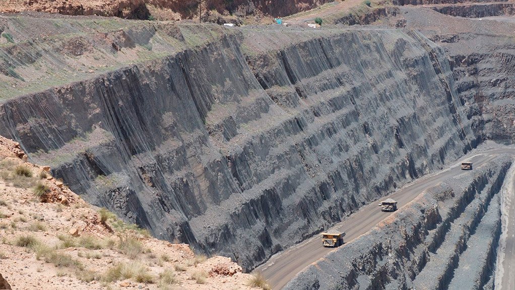
Software from 3D Laser Mapping allows accurate slope monitoring through wire mesh and netting


This article has been supplied.
The use of wire mesh or safety netting can often limit the ability to capture detailed measurements of a rock surface resulting in poor or inaccurate information regarding the movement of the slope. SiteMonitor4D from 3D Laser Mapping uses unique market-leading technology to combat this problem. When steeply sloping rock faces break into fragments and release rock debris, close fitting wire mesh and netting is often anchored to the slope face. Vegetation can take root and cause an obstruction to systems trying to measure movement on the slope face itself. SiteMonitor4D can work around these obstructions by using a unique function to record multiple targets for each measurement. This precise and high-accuracy laser ranging is based upon echo digitisation and online waveform processing.
This technology, alongside the small footprint of LiDAR, enables measurements of the wire mesh (first target) and the slope (last target) to be returned. SiteMonitor4D software automatically filters these measurements so that only data from the slope face is analysed.
Unstable rock faces can be monitored extensively, without the need to compromise existing safety measures achieved through applying wire mesh or netting. "SiteMonitor4D can resolve rock fall accumulation and debris movement behind the mesh which can often indicate slope instabilities, even on slopes with over 60% of their surface covered in mesh" commented Dr Sarah Owen, LiDAR Systems Engineer at 3D Laser Mapping. Monitoring through wire mesh doesn’t have to be a nearly impossible, time-consuming task – a SiteMonitor4D system from 3D Laser Mapping can be used for automatic, accurate slope monitoring with ranges up to 4km away from the slope face.
If you want to carry out detailed, automated slope stability analysis and want to find out more – please get in touch via the contact details below. 3D Laser Mapping employs a team of monitoring specialists who would love to discuss your challenges with you.
Article Enquiry
Email Article
Save Article
Feedback
To advertise email advertising@creamermedia.co.za or click here
Research Reports
Projects

Latest Multimedia
Latest News

Showroom
Multotec, recognised industry leaders in metallurgy and process engineering help mining houses across the world process minerals more efficiently,...
VISIT SHOWROOM
We at Hawk High Pressure Pumps specialise in industrial pumps and pumping systems. Our high pressure washing equipment is locally manufactured and...
VISIT SHOWROOM

Press Office
Announcements
What's On
Subscribe to improve your user experience...
Option 1 (equivalent of R125 a month):
Receive a weekly copy of Creamer Media's Engineering News & Mining Weekly magazine
(print copy for those in South Africa and e-magazine for those outside of South Africa)
Receive daily email newsletters
Access to full search results
Access archive of magazine back copies
Access to Projects in Progress
Access to ONE Research Report of your choice in PDF format
Option 2 (equivalent of R375 a month):
All benefits from Option 1
PLUS
Access to Creamer Media's Research Channel Africa for ALL Research Reports, in PDF format, on various industrial and mining sectors
including Electricity; Water; Energy Transition; Hydrogen; Roads, Rail and Ports; Coal; Gold; Platinum; Battery Metals; etc.
Already a subscriber?
Forgotten your password?
Receive weekly copy of Creamer Media's Engineering News & Mining Weekly magazine (print copy for those in South Africa and e-magazine for those outside of South Africa)
➕
Recieve daily email newsletters
➕
Access to full search results
➕
Access archive of magazine back copies
➕
Access to Projects in Progress
➕
Access to ONE Research Report of your choice in PDF format
RESEARCH CHANNEL AFRICA
R4500 (equivalent of R375 a month)
SUBSCRIBEAll benefits from Option 1
➕
Access to Creamer Media's Research Channel Africa for ALL Research Reports on various industrial and mining sectors, in PDF format, including on:
Electricity
➕
Water
➕
Energy Transition
➕
Hydrogen
➕
Roads, Rail and Ports
➕
Coal
➕
Gold
➕
Platinum
➕
Battery Metals
➕
etc.
Receive all benefits from Option 1 or Option 2 delivered to numerous people at your company
➕
Multiple User names and Passwords for simultaneous log-ins
➕
Intranet integration access to all in your organisation