Position of strategic transmission corridors confirmed
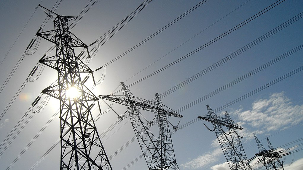

FUTURE BACKBONE The transmission corridors were identified in support of Strategic Integrated Project 10 pertaining to electricity transmission and distribution
STRATEGIC TASK The Council for Scientific and Industrial Research, the South African National Biodiversity Institute and Eskom were tasked to identify the strategic routing corridors


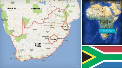
South African research institute the Council for Scientific and Industrial Research (CSIR), in collaboration with the South African National Biodiversity Institute (Sanbi) and State-owned power utility Eskom, has confirmed the final position of the five strategic transmission corridors in the past two months.
The Department of Environmental Affairs appointed the CSIR and Sanbi to undertake a strategic environmental assessment (SEA) to identify strategic routing corridors. “The corridors are representative of South Africa’s future transmission backbone up to 2040. The corridors were identified to support Strategic Integrated Project 10 (SIP 10), which pertains to electricity transmission and distribution.
“Given the strategic importance of these corridors in balancing the country’s future generation and load requirements, the SEA is advocating that electricity grid infrastructure development inside of the corridors benefit from improved regulatory treatment in the form of faster and more efficient environmental authorisation and permitting procedures,” says CSIR project manager for the electricity grid infrastructure (EGI) SEA Marshall Mabin.
SIP 10 has been identified by the Presidential Infrastructure Coordinating Committee as a key energy-related deliverable of South Africa’s National Infrastructure Plan and the overarching National Development Plan.
The initial position of the corridors at the start of the SEA was based on the output of Eskom’s 2040 Strategic Grid Plan study, a detailed study to determine priority corridors for transmission level expansion, explains Mabin.
“Through detailed spatial assessment of the initial corridors and surrounding areas, the project team has refined the position of the corridors to enhance opportunities for development, such as unlocking areas of identified future generation or load potential,” he says.
These corridors were also refined to reduce the extent of environmental and engineering constraints within the corridors, Mabin adds, noting that typical environmental and engineering constraints impacting on grid infrastructure development include protected areas and steep slopes.
Project Details
The SEA project work involved a detailed spatial mapping exercise, based on the manipulation of geographic information system data collected from a range of sources in the past 12 months, Mabin says.
The mapping approach included negative mapping (called Phase 1a) to identify key environment- and engineering-related constraints to electricity grid infrastructure development; and positive mapping (called Phase 1b), which involved identifying areas where transmission- level infrastructure might be best used from an energy-generation and an electricity-demand perspective.
The environmental component of the negative mapping exercise was significantly informed by spatial data, focusing on information regarding environmental sensitivities such as the Cape Vulture colonies and World Heritage Sites. This information was provided by national and provincial departments, environmental agencies and nongovernmental organisations, Mabin highlights.
A similar exercise was undertaken for engineering constraints, such as environmental features impacting on the construction or operation of electricity- grid infrastructure and which likely require an engineering solution, he notes, adding that constraints include steep slopes greater than a 40° incline or rivers and wetland features larger than 500 m in diameter. The Eskom line-engineering team informed this stage of the assessment.
“Spatial data on key areas of planned or significant development potential for the positive mapping exercise was gathered through a review of national, provincial and local government planning documentation and consultation with state enterprises and the private sector,” Mabin says.
Key considerations included the location of proposed strategic economic zones, unexploited mining areas and potential development areas of interest to independent power producers.
The results of the two exercises were consolidated to determine the optimal and final location of the corridors in Phase II, which was completed in February this year, Mabin says.
The optimal position of the corridors in the context of this study is a location that best supports areas demonstrating development potential while achieving the aims of reducing the environmental-impact risk and costs associated with construction and maintenance of infrastructure, he adds.
The EGI SEA is currently in its final phase (Phase III), which involves environmental specialists undertaking scoping-level assessments of the corridors to develop four-tiered environmental sensitivity maps of the corridor extent for environmental aspects such as birds, visual impact, heritage and terrestrial and aquatic biodiversity.
The maps will provide Eskom with an indication of the relative environmental sensi- tivity of different areas inside the corridors.
The maps, in combination with a development protocol or guideline document, will inform the additional levels of environmental assessment that Eskom will be required to undergo at different locations in the corridors before environmental authorisation for EGI development should be considered.
Mabin concludes that completion of Phase III is planned for December 2015.
Article Enquiry
Email Article
Save Article
Feedback
To advertise email advertising@creamermedia.co.za or click here
Research Reports

Projects
Latest Multimedia
Latest News

Showroom

Columbus Stainless, based in Middelburg, Mpumalanga, is Africa’s only producer of stainless steel flat products. In addition, Columbus is the only...
VISIT SHOWROOM
Occupational health services, mobile clinics, wellness campaigns, aviation.
VISIT SHOWROOM


Announcements
What's On
Subscribe to improve your user experience...
Option 1 (equivalent of R125 a month):
Receive a weekly copy of Creamer Media's Engineering News & Mining Weekly magazine
(print copy for those in South Africa and e-magazine for those outside of South Africa)
Receive daily email newsletters
Access to full search results
Access archive of magazine back copies
Access to Projects in Progress
Access to ONE Research Report of your choice in PDF format
Option 2 (equivalent of R375 a month):
All benefits from Option 1
PLUS
Access to Creamer Media's Research Channel Africa for ALL Research Reports, in PDF format, on various industrial and mining sectors
including Electricity; Water; Energy Transition; Hydrogen; Roads, Rail and Ports; Coal; Gold; Platinum; Battery Metals; etc.
Already a subscriber?
Forgotten your password?
Receive weekly copy of Creamer Media's Engineering News & Mining Weekly magazine (print copy for those in South Africa and e-magazine for those outside of South Africa)
➕
Recieve daily email newsletters
➕
Access to full search results
➕
Access archive of magazine back copies
➕
Access to Projects in Progress
➕
Access to ONE Research Report of your choice in PDF format
RESEARCH CHANNEL AFRICA
R4500 (equivalent of R375 a month)
SUBSCRIBEAll benefits from Option 1
➕
Access to Creamer Media's Research Channel Africa for ALL Research Reports on various industrial and mining sectors, in PDF format, including on:
Electricity
➕
Water
➕
Energy Transition
➕
Hydrogen
➕
Roads, Rail and Ports
➕
Coal
➕
Gold
➕
Platinum
➕
Battery Metals
➕
etc.
Receive all benefits from Option 1 or Option 2 delivered to numerous people at your company
➕
Multiple User names and Passwords for simultaneous log-ins
➕
Intranet integration access to all in your organisation