Hydropedology and how it relates to wetlands


This article has been supplied.
(Virtual Showroom): Development stressors and anthropogenic activities in South Africa such as commercial, residential, and linear development, as well as mining related activities (which is required for the economic growth), has changed the landscape of South Africa. Anthropogenic changes to landscape over natural or relatively natural landscape, has an impact on the previously unquantified relationship between the soil-hydrology interface downslope and thus the watercourses typically found in the valley of the landscape. Part of Wetland Ecology studies in South Africa, the watercourses that are considered to being potentially or actually impacted by anthropogenic activities are typically assessed in isolation and does not completely consider the broader catchment area, which essentially drives these watercourses. Hydropedology as a science aims to define and utilise the soil-hydrology link within terrestrial environments, which are upslope of watercourses to aid in the preservation and management of watercourses in associated valleys.
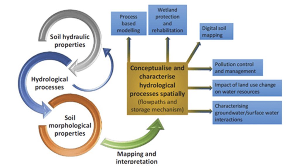
The Department of Human Settlements, Water and Sanitation (DHSWS) has recently stressed the importance of Hydropedology as a science, which is imperative to the preservation and management of watercourses. Furthermore, the Water Research Commission (WRC) (2019) defines hydropedology ‘as the study of the hydrological interaction of water with soil and the fractured rock zone.’ Its application essentially makes it possible to identify water resources and flow paths within the hillslope of a watercourse from the upper limits (crest) to the lower limits (within watercourse). According to van Tol et al (2019), Figure 1 describes and illustrates the inputs, outputs and uses of hydropedology:
A hydropedology study is important in terms of the physical characteristics of the different soil forms. The porosity, conductivity and morphological properties of a soil profile can be utilised to determine the dominant hydrological processes through a profile and thus the hillslope hydrology. Hydrological processes such as storage, water flow paths and connectivity between different flow paths can be characterised and conceptualised. The conceptualisation of the hydrological processes allows for more informed planning and management of watercourses in the valley by taking into consideration the catchment related flows.
Soil horizons and forms are classified into five (5) hydrological soil types, which are (van Tol et al., 2013):
- Recharge zone,
- Interflow zone between A and B horizons,
- Interflow between soil and bedrock,
- Responsive shallow soil, and
- Responsive saturated soil.
There is a common conceptual hydrological flow path that are found in different hydrological soil types. At a broad level, soil horizons and forms are classified into three (3) different types which are described and defined below:
- Recharge zone: Soils that typically do not show any signs of wetness and are well drained soils in which the dominant flow direction is vertical through the soil and out of the profile, typically into the underlying bedrock.
- Interflow (A/B) zone: Soils that typically have a less permeable B horizon, which facilitates the build-up of water in the topsoil and the lateral flow downslope at the interface between the horizons.
- Responsive zone: Soils which typically do not encourage significant storage of water, and thus are characteristic by overland flow after rainfall events.
This flow paths during a rainfall event will result in the recharge zone flow path being vertical until reaching the bedrock and then typically lateral when reaching bedrock. The interflow zone flow path being a mixture of vertical and lateral flow through the soil profile and predominantly lateral through the bedrock. Finally, the responsive zone flow path will collect water via the fractured bedrock and laterally through the interflow zone. The flow path through the responsive zone is typically lateral.
The hydrological soil types all have different hydrological responses depending on the soil properties and its position within the hillslope. Dependent on the hydrological soil types classification within a single hillslope catena, the hillslope can be classed into six (6) different classes namely:
- Class 1: Interflow (Soil/Bedrock Interface),
- Class 2: Shallow Responsive,
- Class 3: Recharge to groundwater (not connected),
- Class 4: Recharge to wetland,
- Class 5: Recharge to mid-slope (typical of a hillslope seepage wetland), and
- Class 6: Quick interflow.
By understanding the dominant hydrological processes within a soil profile, any planned development on a catchment of the slope can be planned to ensure proper preservation efforts are conducted to reduce impacts on the drivers, which sequentially feed the watercourses within the valley. An example of the importance of classing soil profiles is if a hillslope has been classified as a Class 1 (Interflow soil/bedrock) it can be assumed that a wetland situated at the valley bottom is primarily fed by lateral flow through the soil profile, atop the fractured bedrock. If a large opencast coal mine is planned within the section of the hillslope that has been classified as interflow hydrologic soils, the complete excavation of this section of the hillslope may result in the absence of flow to, and destruction of, the wetland situated in the valley bottom.
In addition to this, the fate of different pollutants can be estimated depending on what hydrological soil type it is spilled on. Furthermore, if a spill were to occur on a recharge soil, it is likely to flow vertically into the groundwater, or into the wetland at the valley bottom several months later via the fractured bedrock. However, if spilled on an interflow soil it will travel laterally in flow through the soil profile, which may result in the toxicant being filtered out by various chemical interactions with microorganisms in the soil.
Hillslope water resource contributions to wetlands vary in both quantity and timing. The duration of time that the water resource is held in the terrestrial hillslope may be one of the most important drivers of watercourse hydroperiod. The time between rain falling on the hillslope crest and the same water reaching the watercourse within a valley may be a period that can be measured in days or may be as slow as years (Figure 3). This implies a set of controls in the water supply zone (terrestrial controls), in the transition zone to the wetland (terrestrial controls), and in the receiving and discharge zone (watercourse controls). The storage capacity of soils in the catchment is of utmost importance, as these controls drive and forms wetlands in the valleys. Thus, this knowledge of hydroperiod is essential for managing development in the catchment and how the potential losses can be re-established when development has to occur.
The importance of the application of hydropedology are evident in practice, which can change the way hydrological processes within the soil profile are utilised to plan and coordinate several activities within the altered catchment areas of South Africa.
ENVASS strives on recognizing the importance of this science and its application for the preservation and management of landscapes. Please do not hesitate to contact ENVASS to undertake hydropedology studies, which include buffer zone determination for watercourses, watercourse flow requirements, hillslope classification and planning of different land uses.
Article Enquiry
Email Article
Save Article
Feedback
To advertise email advertising@creamermedia.co.za or click here
Research Reports

Projects


Latest Multimedia

Latest News

Showroom

M and J Mining are leading suppliers of physical support systems as used by the underground mining industry. Our selection of products are not...
VISIT SHOWROOM
Astore Keymak is one of South Africa’s leading suppliers of high-quality Thermoplastic Pipeline Systems, with branches in the major provinces.
VISIT SHOWROOM


Press Office
Announcements
What's On
Subscribe to improve your user experience...
Option 1 (equivalent of R125 a month):
Receive a weekly copy of Creamer Media's Engineering News & Mining Weekly magazine
(print copy for those in South Africa and e-magazine for those outside of South Africa)
Receive daily email newsletters
Access to full search results
Access archive of magazine back copies
Access to Projects in Progress
Access to ONE Research Report of your choice in PDF format
Option 2 (equivalent of R375 a month):
All benefits from Option 1
PLUS
Access to Creamer Media's Research Channel Africa for ALL Research Reports, in PDF format, on various industrial and mining sectors
including Electricity; Water; Energy Transition; Hydrogen; Roads, Rail and Ports; Coal; Gold; Platinum; Battery Metals; etc.
Already a subscriber?
Forgotten your password?
Receive weekly copy of Creamer Media's Engineering News & Mining Weekly magazine (print copy for those in South Africa and e-magazine for those outside of South Africa)
➕
Recieve daily email newsletters
➕
Access to full search results
➕
Access archive of magazine back copies
➕
Access to Projects in Progress
➕
Access to ONE Research Report of your choice in PDF format
RESEARCH CHANNEL AFRICA
R4500 (equivalent of R375 a month)
SUBSCRIBEAll benefits from Option 1
➕
Access to Creamer Media's Research Channel Africa for ALL Research Reports on various industrial and mining sectors, in PDF format, including on:
Electricity
➕
Water
➕
Energy Transition
➕
Hydrogen
➕
Roads, Rail and Ports
➕
Coal
➕
Gold
➕
Platinum
➕
Battery Metals
➕
etc.
Receive all benefits from Option 1 or Option 2 delivered to numerous people at your company
➕
Multiple User names and Passwords for simultaneous log-ins
➕
Intranet integration access to all in your organisation