Geospatial mapping offers range of underground mining solutions


New three-dimensional (3D) scanning and geospatial mapping technologies aim to provide innovative solutions to help mine owners and workers overcome everyday hurdles faced in the mining industry, including improving accessibility to ensure worker safety, speeding up operations and giving insights into the changing underground environment by delivering precise and real-time data.
Global geospatial mapping specialist, GeoSLAM, has expanded its mining offering to provide advanced underground mining solutions. The company recently unveiled its automated processing platform, GeoSLAM Connect, which allows users to process data to their exact specifications through a series of interactive, customisable script-based workflows. Features such as automatic georeferencing are said to be particularly useful for the mining sector, including the automatic georeferencing.
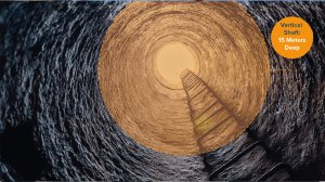
New innovations include production progress mapping, convergence analysis and vertical mine shaft inspection monitoring - all additions to existing solutions currently available and in use across the globe, including GeoSLAM Volumes for stockpile volumetric calculations.
Commenting on the launch of the new mining solutions, GeoSLAM CEO and founder Graham Hunter explains: “We’ve worked in the mining sector for a number of years, alongside the industry’s major worldwide players to understand their needs and challenges so I’m delighted to announce our latest offering, supported by our state-of-the-art Connect software, that will continue to bolster our mining offering.”
“These innovations are designed to be operated using our existing ZEB family of scanners and, best of all, the ease of use means they can be used without any prior training. In just a matter of minutes, with no interruption to the mining teams, mine owners can have reliable and accurate data at their fingertips, saving both time and money in what is an already demanding sector,” he added.
The company’s Production Progress Mapping application, when coupled with a ZEB scanner and its own internal coordinate system, aims to give operators the flexibility to make short-term operational decisions on newly-mined production areas in quick time in a ‘mining-to-plan’ process. Once the data from each scan has been automatically processed and georeferenced using GeoSLAM Connect, it can be uploaded to any compatible third-party software. The platform will allow operators to overlap collected data and precisely visualise changes of an area over time to compare with project plans – giving mine owners the freedom to analyse, make real-time decisions and avoid production hold-ups.
Digital technologies such as GeoSLAM’s new Convergence Analysis aim to provide mine owners with a rapid and cost-effective way to understand the environment while keeping miners safe. Its simultaneous localisation and mapping, or SLAM, algorithm is designed to create clear 3D visualisations, giving mine operators the ability to quickly and safely measure rock support, including detecting failure points, the velocity of change, potential slope and areas of displacement.
The company’s purpose-built shaft inspection cradle, built for collecting data from above ground during inspections and analysing change, allows users to understand the erosion of a shaft wall, view blockages and identify hanging points for ore in hard-to-reach and dangerous vertical shafts.
The GeoSLAM Care support package comes standard with ZEB scanners and offers mining customers access to hardware and remote software support, the latest software releases, and access to GeoSLAM Academy – a portal of customer resources that includes user training, videos and best practice information.
Article Enquiry
Email Article
Save Article
Feedback
To advertise email advertising@creamermedia.co.za or click here
Research Reports

Projects

Latest Multimedia
Latest News

Showroom
As one of South Africa's leading manufacturers, Bell Equipment distributes and exports its wide range of heavy equipment globally to mining,...
VISIT SHOWROOM
From batteries for boats and jet skis, to batteries for cars and quad bikes, SABAT Batteries has positioned itself as the lifestyle battery of...
VISIT SHOWROOM
Announcements
What's On
Subscribe to improve your user experience...
Option 1 (equivalent of R125 a month):
Receive a weekly copy of Creamer Media's Engineering News & Mining Weekly magazine
(print copy for those in South Africa and e-magazine for those outside of South Africa)
Receive daily email newsletters
Access to full search results
Access archive of magazine back copies
Access to Projects in Progress
Access to ONE Research Report of your choice in PDF format
Option 2 (equivalent of R375 a month):
All benefits from Option 1
PLUS
Access to Creamer Media's Research Channel Africa for ALL Research Reports, in PDF format, on various industrial and mining sectors
including Electricity; Water; Energy Transition; Hydrogen; Roads, Rail and Ports; Coal; Gold; Platinum; Battery Metals; etc.
Already a subscriber?
Forgotten your password?
Receive weekly copy of Creamer Media's Engineering News & Mining Weekly magazine (print copy for those in South Africa and e-magazine for those outside of South Africa)
➕
Recieve daily email newsletters
➕
Access to full search results
➕
Access archive of magazine back copies
➕
Access to Projects in Progress
➕
Access to ONE Research Report of your choice in PDF format
RESEARCH CHANNEL AFRICA
R4500 (equivalent of R375 a month)
SUBSCRIBEAll benefits from Option 1
➕
Access to Creamer Media's Research Channel Africa for ALL Research Reports on various industrial and mining sectors, in PDF format, including on:
Electricity
➕
Water
➕
Energy Transition
➕
Hydrogen
➕
Roads, Rail and Ports
➕
Coal
➕
Gold
➕
Platinum
➕
Battery Metals
➕
etc.
Receive all benefits from Option 1 or Option 2 delivered to numerous people at your company
➕
Multiple User names and Passwords for simultaneous log-ins
➕
Intranet integration access to all in your organisation