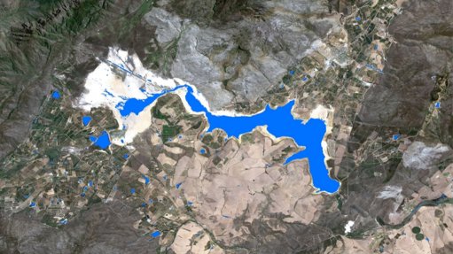
THEEWATERSKLOOF DAM WESTERN CAPE Water is going to be the kingpin in just about every decision-making sector
The website application Mzansi Amanzi (isiZulu translation of Water South Africa), has the capabilities to monitor and provide insight on surface-water resources across South Africa on a monthly basis, says Mark Thompson, the director of the earth observation technology company GeoTerraImage.
The objective of our solution is to create a one-stop shop for water intelligence, as well as, within the coming months, integrating the ability to convert surface areas into volume with the assistance of EkoSource, he adds.
The water monitoring solution, which has been operational since October 2017, enables users to determine the extent of surface water using satellite imagery. GeoTerraImage has partnered with a water management services company called EkoSource to determine volumetric water estimates from detected surface water bodies. The volumetric estimates will further enable users to see how much water is in each water catchment and not only where it is located. This adds further detail of information such as the locality and availability of surface water.
The cloud-based satellite image data archives coupled with a proprietary algorithm and big data processing capabilities, produce spatially-detailed information on the extent of all surface-water features, on a monthly basis.
Information that could previously be gained only by using on-site measurements and equipment, with all the associated costs and constraints, can now be gathered in near real time over significantly larger areas using earth observation, says Thompson.
“. . . gathering information on the spatial dynamics of certain water-surface areas is vital in terms of making estimations for the management of water and is gradually becoming more important,” says EkoSource director Jason Hallows.
The website is publicly available and provides visuals that represent water-surface data as well as associated statistical data on recent and long-term changes. Thompson describes the website as a “visualisation tool”, but adds that the real purpose of the solution is to provide valuable data to decision-makers, such as water managers, hydrologists and conservationists. South Africa is a water-driven economy, and therefore effective management of these resources is key. Using earth observation and technology in this space provides a scalable solution for all stakeholders involved.
“If you think of the importance of water in the South African economy and what it drives and what it supports, given climate change and the likelihood that water is going to become scarcer and scarcer, water is going to be the kingpin in just about every decision-making sector.”
South Africa is advanced in terms of its key decision-makers and experts being able to harness this type of technology and satellite-generated information, using cloud-based archives and processing, notes Thompson.
Mzansi Amanzi plans to incorporate water quality information as an additional information component. Generating water quality information from satellite data is a proven capability, Thompson adds.
“There’s no barrier in terms of technology. The barrier is getting the system operational and accepted as a source of geo-intelligence to the water community,” Thompson adds.