Photo by: Duane Daws
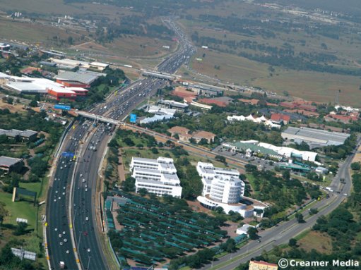
The Gauteng Freeway Improvement Project (GFIP), which included the addition of new lanes to most of the freeways in the province, had succeeded in reducing commuter travel times, historical data by navigation specialist TomTom showed on Tuesday.
The multibillion-rand GFIP faced legal action and social uproar over yet-to-be implemented electronic tolling on the upgraded freeway system.
In a presentation at an Intelligent Transport Society South Africa conference, held in Pretoria, TomTom Africa sub-Saharan Africa account manager Tom Westendorp noted that the cumulative travel time between 16:00 and 19:00 on the 18 km stretch between the Buccleuch interchange and the Old Johannesburg offramp, on the N1 North, had reduced from 23 minutes before the widening of the freeway, in September 2009, to 12 minutes, by August 2011. (Construction on the GFIP was almost one-third completed in September 2009.)
Average pre-GFIP speed on this route had varied between 10 km/h and 85 km/h, increasing to between 65 km/h and 110 km/h post-GFIP.
However, TomTom data showed the freeway around the New Road offramp remained a bottleneck post-GFIP, increasing average travel time by between three and four minutes.
TomTom sells navigation devices to motorists.
“We focus on cars and making the journey as enjoyable as possible,” said Westendorp. “We find the fastest way through traffic. We work on giving people a precise estimated time of arrival.”
TomTom gathered its data from sources such as its own historical traffic-flow monitoring, public information (such as notification of road works), fleet tracking devices, car tracking devices, traffic cameras, mobile phone apps, installed in-car navigation systems and people on the road using TomTom devices.
The company sourced the data, validated it, fused it all together, and returned it to its navigational devices.
The anonymity of the data source was guaranteed.
The main source of data was connected TomTom navigational devices, noted Westendorp, with around 50% of these devices featuring SIM cards that provided their exact location.
In turn, TomTom sent its traffic information to the device, which continuously recalculated the proposed route to find roads offering shorter travel times.
As a motorist was driving, a message would pop up stating that TomTom had found a new, faster route, allowing the driver to switch to that route, said Westendorp.
TomTom had customers in 40 countries and had already sold more than 70-million devices.
“By using TomToms we think we can reduce the average journey times by up to 15%. This saves fuel too,” said Westendorp.
If, however, more and more people used SIM-card navigational devices, it would be possible to move to something called “load-balancing”, where traffic could be spread across all available roads, ensuring an optimal travel time for the majority of commuters.
Another technological change that could permeate society in general, replacing the traditional concept of addresses, was the use of waytags, said Westendorp. The waytag was a South African invention.
It allowed people to direct guests or clients to their homes, offices, current locations, or anywhere else with a single word, rather than an address or set of GPS coordinates.
A waytag was a word preceded by an exclamation mark.
Users could create waytags on their phones and share them using an app, social media, email or SMS. Users could also set privacy restrictions for each waytag and limit visibility to approved users. It was also possible to add traditional contact and address information to a waytag.
By combining waytags with mapping solutions on various devices, users could eventually be able to navigate their way to any waytag by tapping on it on their smartphones, for example.