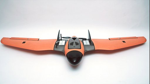
Cape Town-based aerial surveying and remote-sensing specialist Aerovision South Africa is the developer of the ALTiMapper AV-01, a remotely piloted fixed-wing mapping aircraft. The company also undertakes custom builds for various commercial remotely piloted aircraft system (RPAS) applications.
Based on a well-proven wing-type airframe, the ALTiMapper AV-01 is an extremely durable, affordable and easy to use RPAS mapping platform that is packed with features, usually only seen in high-end platforms.
“We designed the AV-01 with the end-user in mind, but simultaneously provide a stable and reliable platform for accurate, high-quality geo-referenced imaging,” says Aerovision SA CEO and founder Ian Freemantle.
He notes that the company was looking for a cost-effective RPAS mapping platform that would handle tough conditions and still provide good, reliable data. “The AV-01 was built on our experience and knowledge in the field.”
With a 1.95 m wingspan, the ALTiMapper AV-01 is capable of up to 90 minutes flying time at a cruising speed of 60 km/h and is able to cover more than 300 ha in a single flight.
Using the highly rated open-source Mission Planner software, the AV-01 is capable of fully autonomous missions from takeoff to landing.
The AV-01 uses the highly accurate and reliable Pixhawk 2.1 Cube autopilot system with the latest UBLOX NEO-M8N GPS module for precise flight paths and accurate image geo-tagging. For more precise mapping solutions, a real-time kinematic system is optional.
The AV-01 payload bay is designed to fit the Sony a5100 and a6000 cameras as standard. The camera is fully integrated with the flight controller for accurate, distance-based auto triggering. A modified near-infrared version of the Sony a5100 is also available.
The payload bay can easily be customised to fit many other cameras and multi-spectral sensors.
The ALTiMapper AV-01 is a complete solution, with each aircraft flight tested and custom tuned before being shipped.
Training options, from beginner to advanced level, are provided on a customised basis. Aerovision also offers a data-processing and analysis support service for achieving meaningful results.